Matthew Gonzalez

Hi, my name is Matthew, and I’m a GIS enthusiast from Menifee, CA. I have interests in data science, computer science, and environmental science alongside GIS. Through the lens of GIS, I have been able to grow in each of these fields and build on my foundation of knowledge.
Q. When did you first discover GIS?
A. I first discovered GIS during my undergraduate studies at UC San Diego. I took an introductory class and was instantly intrigued. After getting my B.S. degree, I have continued to pursue this field, both personally and professionally. My current schooling at MSJC has given me a greater appreciation for the various uses and applications possible through GIS.
Q. What inspired you to study GIS?
A. When I took my first GIS class, I was already studying geology, and had some experience reading and studying maps. For subjects like geophysics or structural geology, maps made learning tough concepts much more accessible. That gave me my initial appreciation for the importance of GIS to adjacent fields. From that point on, my classes and work experience in this field have continued to impassion me on learning and doing more with this technology.
Q. What has been a GIS highlight on your educational path?
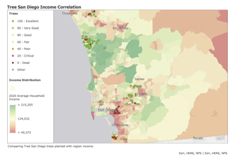
A. During my internship with the nonprofit Tree San Diego, I created a Community Impact Report to assess the ability of the organization to provide trees for underserved communities. By using spatial data I personally collected, I was able to conclude that they were accomplishing this goal. Going through the data collection process and finding real answers was extremely rewarding, and only possible through the use of GIS software. (I’ve posted this and other projects on my website: https://4mmgonzal.github.io/ )
Q. Do you have a professor/mentor that has inspired you down a specific path in GIS?
A. Yes. My current professor, Emina Sulych, has been amazing in both seeing potential in me and providing opportunities for me to look into regarding GIS. Given my past academic interests in data science, she has steered me towards opportunities that suite my strengths.
Q. What do you envision your GIS career looking like?
A. I am motivated by interpretation and analyzation of spatial data to solve real-world issues. As such, positions like GIS Analyst or Specialist intrigue me. With my background, I would love to work in either Environmental or Municipal sectors. Serving my community and the future would bring me great pride.
Q. What is something you have enjoyed as being part of the IEGIS User Group?
A. Having a local community to share my interest in GIS makes me feel closer to the field. a support system is pivotal to the success of this or any industry. As a platform, the organization gives me insight into what my peers are creating, as well as employment opportunities.