Marcia Carrillo Ph.D; GISP

Marcia CarRillo
Marcia Carrillo Ph.D., GISP, is the VP of Tech Services at Psomas, a full services AEC firm that has office throughout the Western US. Prior to working at Psomas Marcia worked as Esri as a senior PM in Utilities and Southern California Edison as a Senior Technical Specialist in GIS enterprise implementation. Marcia has worked on large GIS projects such as TRTP Transmission project, West Mojave GIS Mapping and Owens Lake Dust Mitigation Project.
Q: When did you first discover GIS? Did you have any mentors, classes, colleagues, or professors that inspired you along the way?
A: I discovered GIS at the USDA Salinity lab on the UC Riverside campus. I was working in a Post Doc position on mapping salinity and pesticide concentrations across large farming land. I got “bit” by the GIS bug and never looked back. My first big GIS project was the Owens Lake Dust Mitigation project. It was the wild west days of GIS and GPS which allowed me to explore all of the wonderful aspects of both technologies. I learned GIS mostly on my own, my best mentor was Ed Riegelmann, a GIS Senior Consultant who developed USAF GeoBase programs. He really instilled in me the how important it was to understand how GIS works at the big picture level.
Q: What got your career in GIS started?
A: It was working at CH2M Hill that got my career going in GIS. It was at the time of the transition from the desktop application (ArcInfo 7), to ArcView; and a move to place GIS in the field to collect data. The value of data was just starting to get noticed by large organizations and I was able to really excel my career using data and GIS together to answer questions and show relationships that otherwise were not obvious.
Q: As a VP of Tech Services what does a typical workday look like for you?
A: The GIS team works on various projects such as developing strategic plans, web applications, databases, spatial analyst approaches, etc. I spend most of my time collaborating with my team members to ensure projects are moving along and helping them resolve any issues. My day can be building Ops Dashboards, responding to client questions, and developing scopes of work for various projects.
Q: What GIS project are you most proud of?
A: The project that stands out is the BLM WEMO project. The high-level summary of the project is that the BLM was reviewing OHV impact on the desert tortoise habitat in the West Mojave. Part of this was to map both double, and single-track roads, as well as any recreational sites that were used by the public on BLM land. What makes this project the standout is that we had to collaborate with diverse stakeholders. I taught a group of 15 OHV stakeholders how to use GPS to map roads and quick marks. Over the course of a year we mapped over seven thousand miles of roads and collected over forty thousand quick marks. The data is still in use today which makes me proud of the work we did 15 years ago.
Q: What has been most valuable to you in the GIS sector to learn modern technology or advance your career to the next level?
A: Both are important, to advance my career I had to, and continue to, learn innovative technology to stay current and relevant in the field. Some aspects of my advancement to VP have been about strategic thinking, operations, and people performance. But I would not be an effective VP without staying up to date on modern technology. Also, technology is advancing at a higher rate than ever before, and with AI coming on to the scene, it is more important than ever to stay up to date.
Q: What is something you have enjoyed as being part of the IEGIS User Group?
A: I love hearing about what each member is doing with GIS, how they use the technology, and how GIS has changed the way they do business and the insights they have.

Owens Lake Dust Mitigation
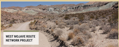
West Mojave Route Network Project